Europe at Night

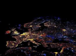
[T]his is actually a composite produced by the National Oceanic and Atmospheric Administration revealing a decade in European economic development and decline.

•  ~1 min to read •  read more  


World from Space, Over the Year

This NASA moving image, recorded by satellite over a full year as part of their Blue Marble Project, shows the ebb and flow of the seasons and vegetation.

•  ~1 min to read •  read more  


Ethnic Canadians

I recently stumbled across this map of “Leading Ethnicity by Census Division,” based on the 2006 Canadian census (original on Wikipedia). Maps fascinate me and I thought this one was pretty cool. I thought I’d share a few thoughts, but first the map itself:

•  ~3 min to read •  read more  


The Shortest Distance is…

The time-old adage is that “The shortest distance between two points is a straight line.” Most of what we see day-to-day would confirm that. On paper, you use a ruler, sometimes called a “straight edge,” to connect two dots. In a field, it’s easy to apply the same principle and cut straight across. But then why do the network maps for the airlines always have those funny looking arcs? What happened to those straight lines?

•  ~3 min to read •  read more